장애물과 분해 - 물, 바이오플라스틱, GPS를 지능적 에이전트로 활용하기
Obstructions & Dissolves – Water, Bioplastic, GPS, and Mountains
이 프로젝트의 연구는 물과 글로벌 위치 시스템(GPS)이 예술 창작 과정에서 내가 마주하는 장벽들을 해소하는 데 활발한 역할을 할 수 있는지 조사하는 것이었다.
해소
이 연구에서 나는 물을 하나의 작용체로 접근했다. 물은 고체를 액체에 용해시켜 용액을 형성할 수 있는 능력이 있기 때문이다. 초기 연구는 물의 전기 전도성을 이해하고, 물이 “다른 어떤 액체보다 더 많은 물질을 용해시킬 수 있는” 방법에 중점을 두었다.1 더 많은 독서를 통해, 물이 현재 우리가 아는 지구를 형성하는 데 중요한 역할을 하는 능동적인 작용체라는 개념적 연결이 이루어졌다.
다차
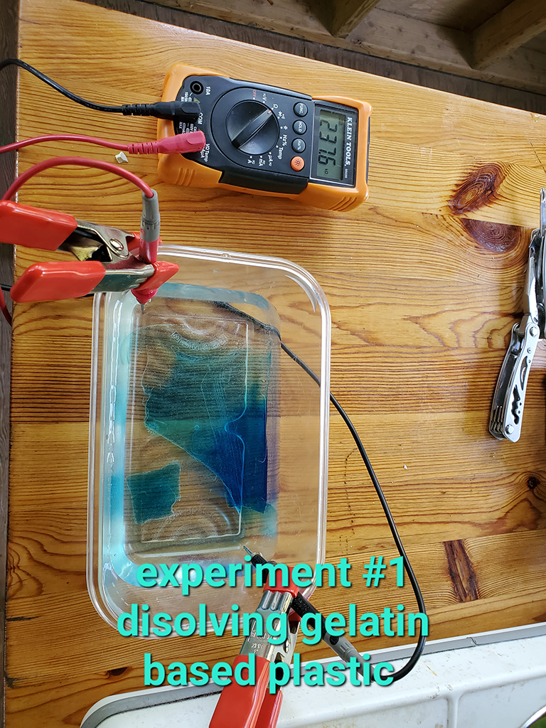
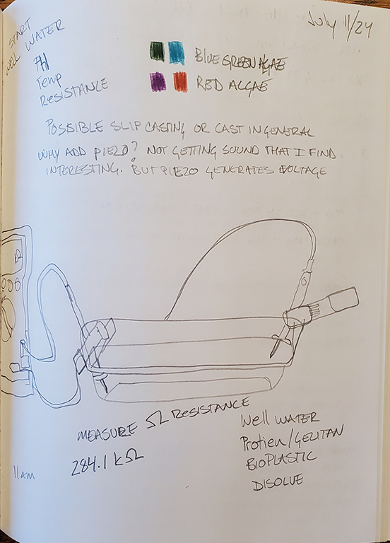
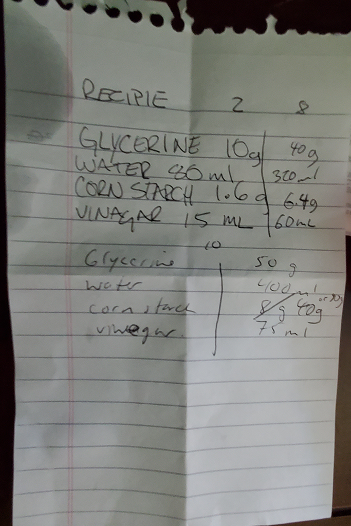
이렇게 물을 실험하기 위해 나는 생분해성 플라스틱으로 용해 가능한 고체를 만들었다. 아이디어는 물에 쉽게 용해되는 고체를 만들면, 시간이 지남에 따라 용해 정도를 측정하고 그 측정을 인터랙티브 설치 작품에서 시간 조정 장치로 사용할 수 있다는 것이었다. 여기서 물은 주제가 아니라 이야기를 이끌어가는 능동적인 작용체이다. 나는 이 실험을 그룹이 만날 전에 가족 다차(별장)에서 진행했다.
1
https://www.usgs.gov/special-topics/water-science-school/science/water-universal-solvent (accessed October 12, 2014)
농장
그룹 레지던시에서 나는 내 연구를 공유하고 모든 예술가들이 함께 하나의 바이오플라스틱 레시피를 만들 수 있도록 워크숍을 개발했다. 그룹은 전분 기반의 바이오플라스틱을 요리하고, 나뭇잎, 씨앗, 음식 색소를 장식 요소로 포함한 고체 형태를 만들었다. 나뭇잎과 씨앗을 사용한 이 작업은 예술가들이 다른 워크숍에서 진행했던 채집 산책과 일치했다.
꿈꾸기
워크숍 후, 나는 연구의 두 번째 요소인 GPS 시스템으로 전환하여 일주일 동안 수집한 데이터에 집중했다.
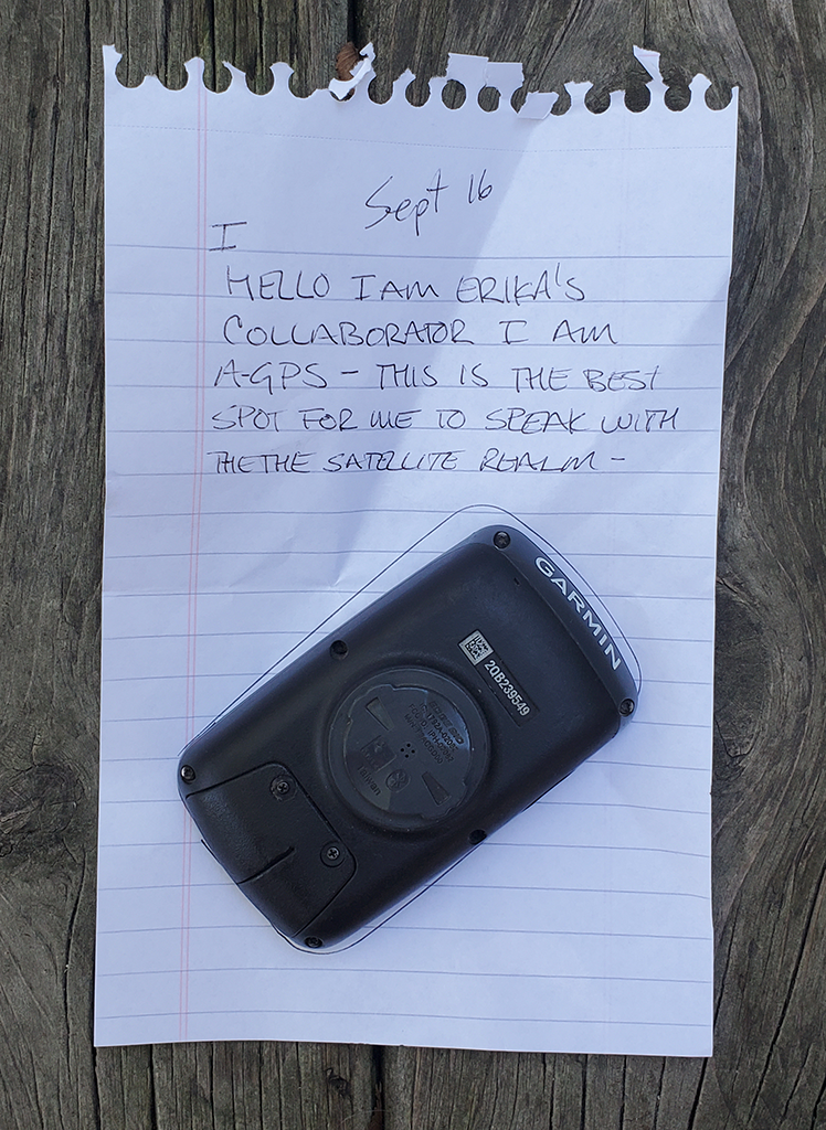
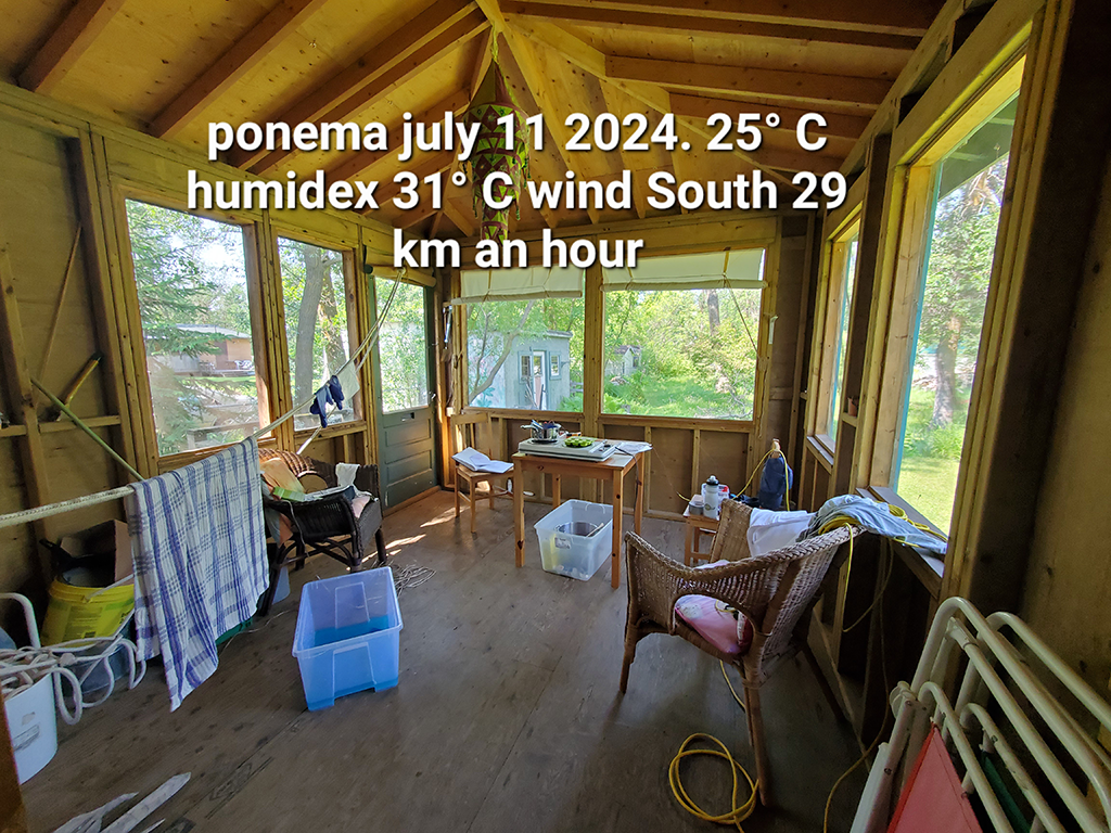
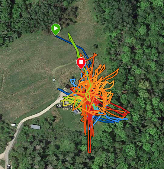
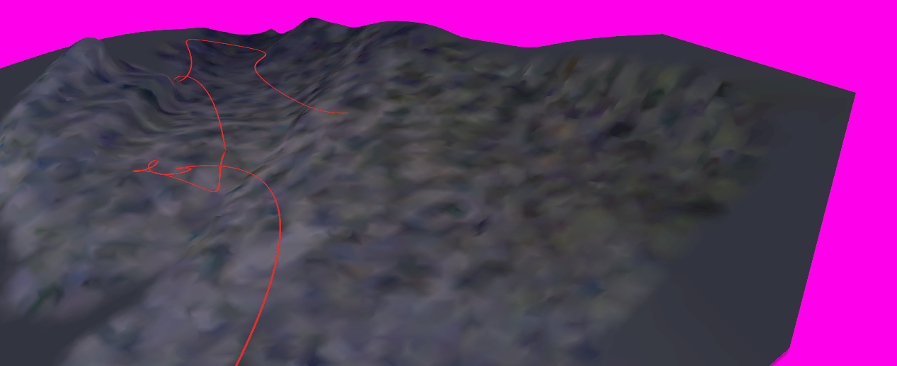
나의 절차는 GPS 수신기를 밤에 켜고 창턱에 놓아두는 것이었다. 내가 자는 동안, GPS는 위성들의 경과를 기록하며 배터리가 다 될 때까지 데이터를 기록한다. 보통 이 과정은 4~5시간 정도의 웨이포인트 데이터를 제공한다. 웨이포인트는 위도, 경도, 고도를 기록한다. 개념적으로 나는 GPS 수신기를 보조 장치로 사용한다. 농장을 둘러싼 산들의 풍경은 내가 접근할 수 없는 곳이었기 때문이다. 육체적으로 내 몸은 더위와 습도를 견디지 못했고, 심리적으로는 숲 속으로 들어가 산을 오르는 것이 두려웠다. GPS는 나의 대리인 또는 대신자가 되어, 내가 잠자는 동안 산을 올라갔다. 아침이 되면 나는 웨이포인트를 그려서 그 여행 경로를 확인했다.
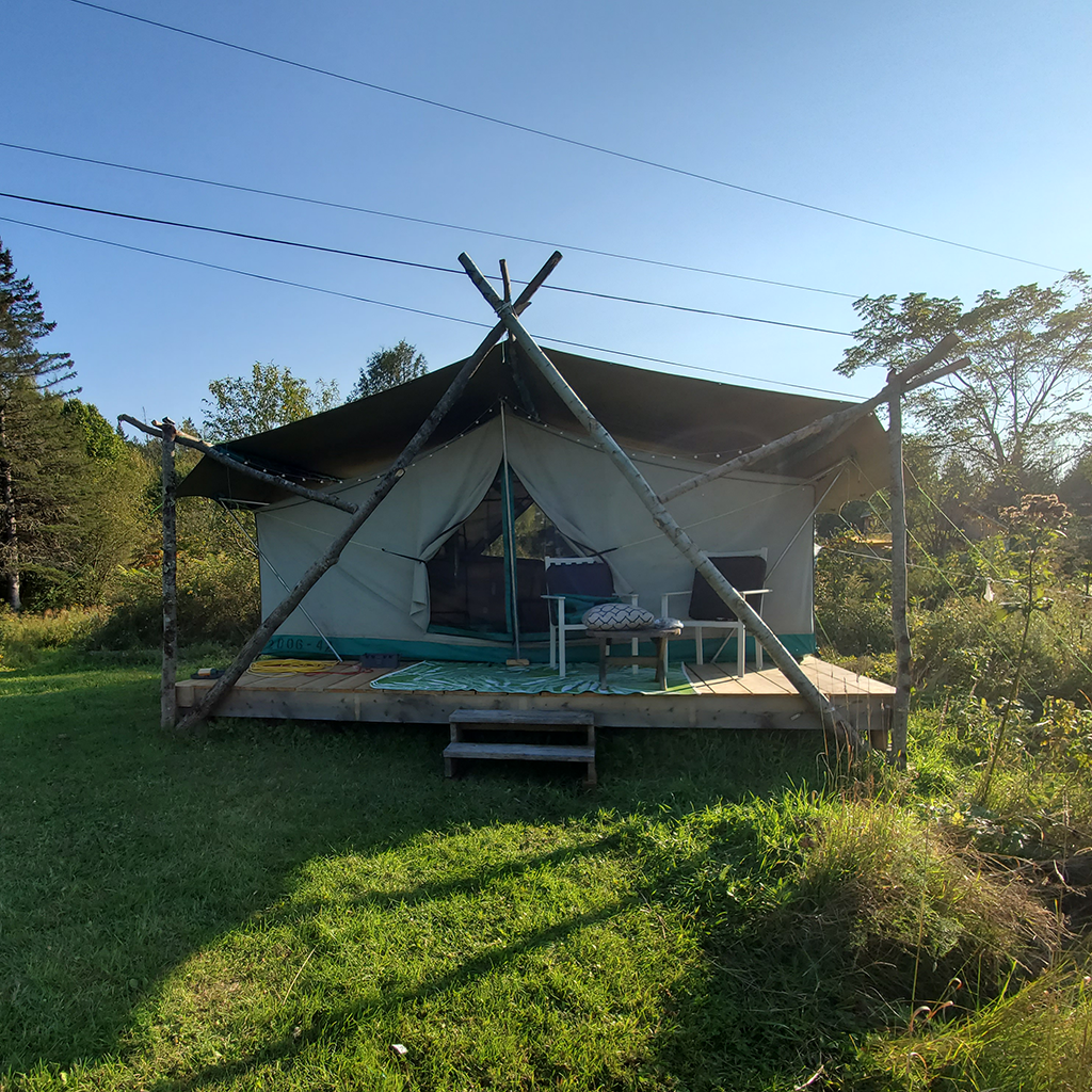
7일째 되는 날, 나는 텐트 플랫폼 그늘에 누워 산을 바라보고 있었다.
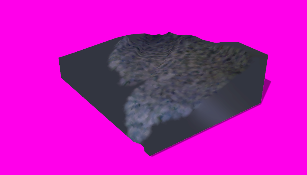
시간이 지난 후, 나는 산의 부피를 반영하는 형태로 내 몸을 위치시키고 싶은 충동을 느꼈다. 이것은 연구 활동의 계획된 부분은 아니었다. 나는 3D 스캐너를 설치하고 20번의 스캔을 진행했다. 나는 내 몸을 위치시키고 그 위에 담요를 덮은 후 스캐너를 작동시켰다. 나는 스캔이 끝날 때까지 천천히 담요를 덮은 몸을 회전시켰고, 스캐너가 추적 참조를 잃는 것이 스캔 종료를 결정짓는 요소였다. 그 후, 메쉬 파일은 스캔 소프트웨어의 알고리즘을 사용하여 고체로 변환되었다.
컴퓨터 작업
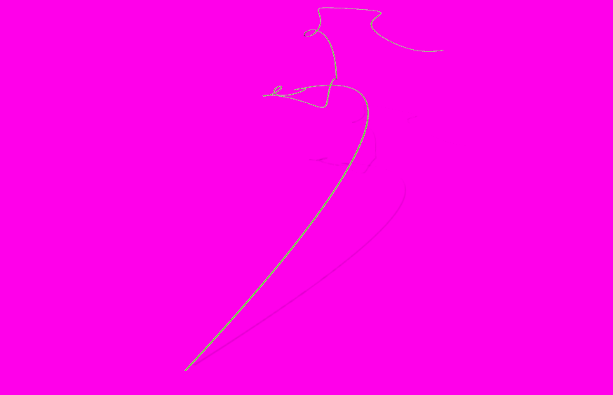
집에 돌아온 후, 나는 GPS 길찾기 데이터를 처리하여 내가 잠든 동안 GPS가 산을 올라갔던 상상 속의 경로를 반영한 3D 모델을 만들었다. 그런 다음, 이 상상 속 경로를 산의 육체적 표현으로 만들어진 3D 모델과 결합했다. 이 결합된 모델들은 GPS 경로를 따라 산을 비행하는 카메라 애니메이션으로 만들어질 것이며, 그 경로를 따라 산의 작은 3D 프린트도 만들어질 것이다.
- 참고 문헌
- Neimanis, Astrida. (2017) Bodies of Water: Posthuman Feminist Phenomenology. London UK: Bloomsbury Academic.
- Bailey-Charteris, Brownwyn. (2024) The Hydrocene: Eco-Aesthetics in the Age of Water. New York USA: Routledge.
- United States Geological Survey. (Accessed October 12, 2024)
- Water Science School. https://www.usgs.gov/special-topics/water-science-school
- moira williams. (Accessed October 12, 2024)https://www.moira670.com
- Petra Kuppers. (accessed October 12, 2024)https://www.petrakuppers.com
- Dunne, Margaret. (2018) Bioplastic Cookbook. textile-academy.org https://issuu.com/nat_arc/docs/bioplastic_cook_book_3/1
The research for this project was to investigate if water and a global positioning system (GPS) could be active agents in the dissolving of barriers that I encounter during artmaking.
Dissolves
For this research I approached water as an agent due to its ability to cause a solid to become incorporated into a liquid forming a solution. Preliminary investigations centered around understanding the electrical conductance of water and how water is capable of dissolving “more substances than any other liquid”.1 With further reading the conceptual connections were made between water as an active agent in forming the earth as we know it now.
The dacha
To experiment with water in this way I made dissolvable solids out of bioplastics. The idea was that if I had a solid that could dissolve easily in water, I could measure the dissolution over time and use that measurement as a timing mechanism in an interactive installation. Here water is not the subject but an active agent that can drive a narrative. I conducted these experiments at my family dacha (cottage) before the group met.
1
https://www.usgs.gov/special-topics/water-science-school/science/water-universal-solvent (accessed October 12, 2014)
The farm
For the group residency at the farm, I developed a workshop that shared my research and invited all the artists to work together to make one of the bioplastic recipes. The group cooked up a starch-based bioplastic and made solid forms incorporating leaves, seeds, and food colouring as decorative elements. This use of leaves and seeds coincided with the foraging walks the artists had taken during the other workshop.
The dreaming
After the workshop I switched to the second element of my research, the GPS system and focused on the data I had gathered over the week.
My procedure was to start the GPS receiver at night and leave it on a windowsill. As I slept, the GPS logged the passing satellites until the battery runs out, this usually gives me four to five hours of waypoint data, the waypoints log position in latitude, longitude, and altitude. Conceptually I use the GPS receiver as an assistive device, the landscape of the mountains surrounding the farm was a place I could not get to. Physically my body was not managing the heat and humidity and psychologically I was afraid to go into the forest and walk up the mountain. The GPS acted as my proxy, or stand-in, traveling up the mountain while I slept. In the mornings I would plot the waypoints and see its travels.
On day seven I was lying in the shade of my tent platform staring at the mountain.
After some time passed, I was struck by an urge to position my body to reflect the volume of the mountain, this was not a planned part of my research activities. I set up my 3D scanner and made 20 scans. I positioned my body then draped a blanket over myself and ran the scanner. I slowly rotated my blanket draped body until the scanner lost its tracking references, this was the factor that determined the end of a scan. The mesh file was then turned into a solid using the scanning software’s algorithm.
The compute
On returning home I processed the GPS wayfinding data into 3D models that reflected the imagined paths the GPS took up the mountain while I slept. I then combined these imagined paths with the 3D models of the embodied manifestations of the mountain. These combined models will be animated with camera fly throughs up the mountain following the GPS paths, small 3D prints of the mountain with their paths will also be created.
- Research references
- Neimanis, Astrida. (2017) Bodies of Water: Posthuman Feminist Phenomenology. London UK: Bloomsbury Academic.
- Bailey-Charteris, Brownwyn. (2024) The Hydrocene: Eco-Aesthetics in the Age of Water. New York USA: Routledge.
- United States Geological Survey. (Accessed October 12, 2024)
- Water Science School. https://www.usgs.gov/special-topics/water-science-school
- moira williams. (Accessed October 12, 2024)https://www.moira670.com
- Petra Kuppers. (accessed October 12, 2024)https://www.petrakuppers.com
- Dunne, Margaret. (2018) Bioplastic Cookbook. textile-academy.org https://issuu.com/nat_arc/docs/bioplastic_cook_book_3/1